
Tanzuft Fm
Type Locality and Naming
Named after Wadi Tanzuft, about 65 km NE of Ghat. (Kilian, 1931; Desio, 1936a, 1936b). Klitzsch (1969) considered the section described by Desio unsuitable for a type section because the lower contact is not exposed there. Therefore, Klitzsch (1969, p. 85) proposed and described a type section at Takarkhouri, 40–50 km southeast of Ghat
References: Kilian, 1931; Desio, 1936a, 1936b; Jacqué, 1963; Klitzsch, 1969; Jaeger & Massa, 1971; Berry et al., 1973; Government of Niger, 1993; Lüning et al., 2000; Mergl et al., 2001; Shalbak, 2015; Hallet, 2002 & 2016.
Synonym: “Schistes à graptolites”. The former name of the formation was spelled Tanezzuft. The spelling was modified to its current form by Hallet (2002) after verifying the official name records of localities in Libya. Jaeger and Massa (1971) separated the lower part of the shales, containing Lower Llandovery graptolites (Rhuddanian) under the name of the “Iyadhar Formation” with the younger shales belonging to the Tanzuft Formation. Because of the lack of direct evidence of the disconformity between the Rhuddanian (bottom) and Aeronian (above), as well as insufficient lithological differences, most authors have not considered the “Iyadhar Formation” to be a valid lithostratigraphic unit (Lüning et al., 2000).
Equivalent(s): Graptolitic Shales of the Tim Mersoï Sub-Basin (Iullemmeden Basin)
Lithology and Thickness
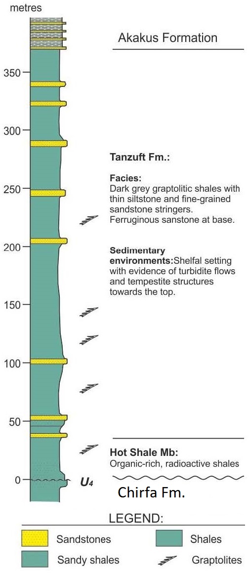
Mainly built up of a thick sequence of graptolitic shales bearing abundant graptoloids, grading upwards to siltstones and sandstones (Figure). Thickness: 402 m at type section; the shales of the Djado region are about 50 to 150 m, possibly up to 250 m thick in outcrops. The sandy rim facies ranges from about 30 to 80 m.
[Figure. Stratigraphic column of the Tanzuft Formation at the Type Locality in Libya (Source: Shalbak, 2015).]
Relationships and Distribution
Lower contact
Unconformably overlies the Chirfa Fm
Upper contact
Conformably overlain by the Akakus Fm
Regional extent
GeoJSON
Fossils
Age
Depositional setting
Marine
Additional Information